|
Microclimate Pilot Study |
|
|
Warm air rises, cold air sinks. Does this work outdoors, too? |

![]() Pilot
Study.pdf is a copy
of the presentation given
Pilot
Study.pdf is a copy
of the presentation given
at the Arkansas Conference on Teaching - Nov, 2004
|
Microclimate Pilot Study |
|
|
Warm air rises, cold air sinks. Does this work outdoors, too? |
![]() Pilot
Study.pdf is a copy
of the presentation given
Pilot
Study.pdf is a copy
of the presentation given
at the Arkansas Conference on Teaching - Nov, 2004
Problem Statement (Phase 1). . . . Have you ever wondered about any of these questions:
What is the effect of the cold water releases from the area dams on our climate?Does the seasonal cold air in the winter settle down into the river valley?
Does the then"warmer" released water affect the bottomland climate?Are the hilltops warmer or colder than the riverbottoms?
Problem Statement (Phase 2) . . . . .
Can we relate water flow to the bottomland temperatures?
Problem Statement (Phase 3) . . . . .
What is the effect of Lake Norfork on surrounding air temperatures?Is the air temperature at the lake less extreme than at school?
Problem Statement (Phase 4) . . . . .
Is the air temperature below the forest canopy less extreme than on the school playground?What is the effect of leaf cover on forest temperatures near our school?
Problem Statement (Phase 5) . . . . .
What is the effect of grass length on surrounding air / soil temperatures?Does the length of grass affect air / soil temperature?
Problem Statement (Phase 6) . . . . .
What is the effect of highest local elevation on surrounding air / soil temperatures?Is the climate on the highest local "mountain" the same as at our school?
Our Norfork Elementary School students are asking these and many more such questions as we study our environment. We have undertaken a study to monitor and record a great deal of atmospheric data in order to answer these questions. The results have surprised us all, and even more questions are being addressed as these are answered. To see how our students are getting their results, view the special GLOBE diurnal graphs whose links are available below:
|
Time Table |
|
15 May 2001 HOBO installed at upland site |
October 2001 USACE granted permit to install datalogger in White River floodplain |
|
2002 |
January 2002 |
February 2002 Bottomland site inaccessible due to flooding |
March 2002 Bottomland flooded again |
|
. |
April 2002 |
5 May 2002 HOBO installed at bottomland site |
June 2002 |
|
. |
August 2002 |
||
|
. |
Battery problems at upland site. Some data losses experienced |
||
|
2003 |
January 2003 |
March 2003 |
|
|
. |
Upland datalogger destroyed by electrical storm on 10 May 2003. Temporary HOBO installed. |
June 2003 - Collection began of daily water releases from both dams upstream of site. |
|
|
. |
July 2003 |
20 August 03 - New HOBO installed at upland site. |
September 2003 Trial of selected water discharge data analysis. Phase 2 of Norfork Microclimate Study started. |
|
. |
October
2003 *** |
November 2003 Initial Phase 3 data available. Winter solstice results, |
December 2003 - Comparison of school vs. lake air temperatures over past two months. 50 cm soil depth graph illustrates seasonal temperature trends. |
|
2004 |
January 2004 |
February 2004 What's happening on 19 Feb 04?** Does wind direction effect lake air temperatures? |
March 2004 - Water temperature datalogger added at Lake Norfork Site. See Figure 8 below |
|
. |
April 2004 - Flood of 24 April on White River washed away the bottomland HOBO and site. high resolution photo |
May 2004. |
June 2004 |
|
. |
July 2004. |
August 2004 Datalogger installed in the forest surrounding our school. |
September 2004. Received a 4-H New Initiative Grant to purchase a datalogger for installation at the club meeting place. |
|
October 2004. |
November 2004 Datalogger installed at Norfork 4-H Club meeting site in tall grass (ATM-05)(unmowed) pasture area. Presentation made at the Arkansas Conference on Teaching. |
December 2004. |
|
|
2005 |
January 2005 Request permission from US Dept of Ag/ US Forest Service to install datalogger on Matney Knob |
February 2005 Arkansas Weyerhauser Mini-Grant funded purchase of Matney Knob hardware. |
March 2005 |
|
. |
April 2005 Approval of US Forest Service to install temperature datalogger at Matney Knob granted. |
May 2005 HOBO Datalogger (ATM-07) installed on Matney Knob. First Data reported. |
June 2005 |
|
. |
July 2005 Vandalism allowed rodents access to chew through sensor leads in the Nature Trail site (ATM-05). |
August 2005 New leads calibrated and forest datalogger ATM-05 re-placed. |
September 2005 - two defective HOBO temperature sensors discovered at Lake Norfork site (ATM-03) 5 and 50 cm depth. awaiting funds for replacement. PIE Max-Min digital thermometer installed at (ATM-01) base weather station. |
|
. |
October 2005 - New vandalism at nature trail forest site discovered and repaired. No data interruptions / loss. |
November 2005 |
December 2005 |
|
2006 |
January 2006 Several elevated air temperature periods noted in Matney Knob data. Student investigations pending. |
February 2006 |
March 2006 - Further temperature anomolies at Matney Knob noted that warrant student analysis. |
|
. |
April 2006 |
May 2006 |
June 2006 - Additional vandalism at nature trail forest site discovered and repaired. |
|
July 2006 - HOBO datalogger installed at PIE base weather station site (ATM-02). PIE Max-Min digital thermometer (ATM-01) leads for (right) soil side malfunctioning. |
August 2006 - Site photos taken at Matney Knob. HOBO installed at PIE field site (ATM-03). |
September 2006 |
|
|
** or *** Indicates phase analysis remarks |
Want to manipulate the data display?
Click on this link April
2003 to access the entire menu driven GLOBE controls.
Click on links above to view full size
graphs and the images below to see full size photos
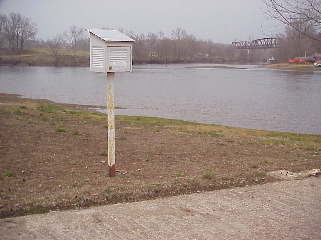
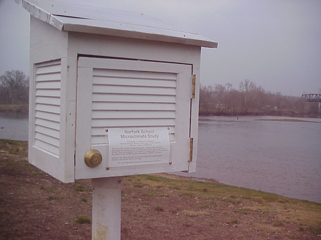
The school weather instrument is housed
in a similar weather resistant package.
 |
 |
 |
|
Figure 1: (above) |
Figure 2: (above) |
Figure 3: (above) |
|
Figure 4: |
Figure 5: Click this link for a map of the study area. |
Figure 6: What's left of the upland datalogger after lightning strike near our weather station at school on 10 May 2003. A replacement datalogger was obtained, calibrated, and installed on 20 August 2003. Bottomland datalogger washed away by flood of 24 April 2004. low resolution photo |
|
Figure 6: |
Figure 7: |
Figure 8: |
Our Methodology ( What we are doing)
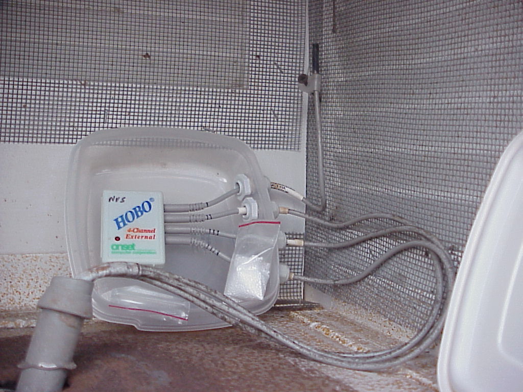
Students are using two (HOBO miniture, computerized, digital, 4-channel) data loggers to record the air and three subsurface soil temperatures around the clock. For the microclimate study, just the air temperatures are being used. Two locations have been chosen to moniter these temperatures. Regularly these instruments are brought to the classroom and the contents are downloaded into the classroom computer where the data is formatted into an e-mail message and sent to the GLOBE Program dataserver in Boulder, Colorado. GLOBE has prepared a software graphics package that displays the data (using a menu driven interface) and allows the students to view and interpret values from both sites at the same time. Thus temperatures are compared against each other simultaneously ( for the same times of day).
The sites being monitored are the school weather station (See a local climatograph at this link) adjacent to the elementary playground (upland) and the old Norfork Ferry Landing site in Norfork Village along the White River (bottomland). The school playground is best described as open mowed grassland with little to no slope adjacent to forested surroundings at about 250 meters above sea level. The river bottom site can be described as an urban-rural interface along and adjacent to the first levee of the floodplain of the White River which has been cleared of most trees and is also covered by mowed grassland. The elevation at the river site is approximately 110 meters above sea level, thus about 140 meters of relief and about two kilometers of horizontal land surface separate the two locations The White River in this area is a cold water stream due to water releases from Bull Shoals dam approximately 22 miles (38 kilometers) upstream. In addition, Norfork Village lies immediately accross from the confluence of the White and North Fork of the White River which is also a cold water stream due to water releases from Norfork Dam, about 5 miles (8 kilometers) up that stream. Both dams release water that varies from nine to eleven degrees Celsius (depending upon season and stored water surface elevations. Due to these cold water releases, a valuable and popular trout fishery has been established in the tailwaters of both dams. See NES Hydro-thon for stream water quality data that has been collected from various points along the White River. During non-discharge periods, river water temperature fluctuates greatly depending upon seasonal temperatures and runoff. A vicinity map of the study area is now available.
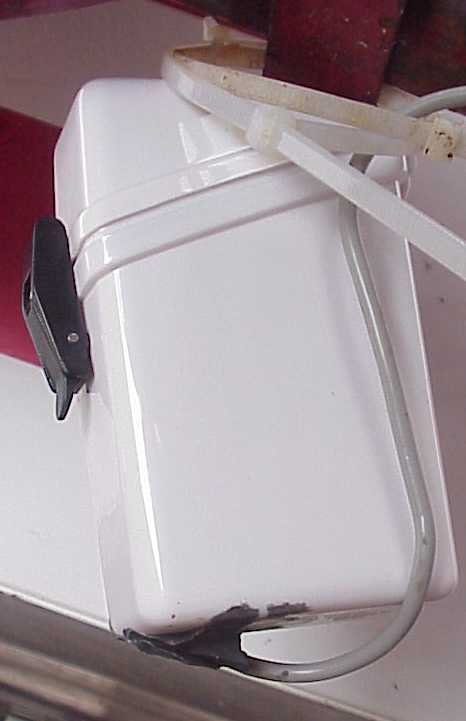
In March 2004, the study (Phase 3) was expanded to include an experiment that was designed to answer what effect the water at Lake Norfork had upon its local environment. A HOBO 2-channel datalogger (Figure 8 above) was installed on the marina about 100 meters out over the lake itself. Measurements were made at the same time as those recorded at the air / soil temperature site at Lake Norfork, about 100 meters landward of the lake shore. In May 2004 heavy rains greatly reduced this landward distance but the basic influence of the water temperature was still compared to that of the air / soil temperature along the lake frontage. A HOBO 2-channel datalogger was used to record the air above and the actual water surface temperatures on the lake. A water temperature probe was inserted about 20 cm below the water's surface for this measurement. The air temperature over the lake was measured by the internal temperature sensor inside the waterproof case which protected the datalogger from condensation and humidity at the site.
Remarks (Partial Data Analysis)
July 2002 - Unusually large runoff from early spring rains necessitated around the clock discharges from all area dams upstream of the study site. Thus the regular pattern of lower night time temperatures along the river.
December 2002 - With the drawdown of area lakes prior to the anticipated flood control season, discharges from the lakes are more random. From the graph of our data significant differences in temperature appeared on 1-2, 15-17, 20-21, and 28-29 December. Why just those days (nights)? From a look at a calendar for that month, these dates are near or following weekends. Historically, generation from dams is reduced or curtailed on weekends. It appears that riverbottom temperatures fall rapidly and farther on such dates Thus on the few such days displayed, a cooling of the riverbottom climate seems to indicate little discharges from upstream. Just the opposite of the typical summer observations.
April 2003 - The dryer than normal spring has meant that releases from the dams are abbreviated, if at all. Thus (again), climate differences are observed on only a few dates this month. The biggest question seems to be what was happening during the period near the end of the month, and in particular from 26-30 April? Students need to rersearch rainfall amounts / dates and discharges from unconrolled streams that drain into the study area. More on this in Phase 2!
50 centimeter soil depth temperatures indicate a much delayed response to fluctuations in air temperatures, thus model relatively longer trends in surface conditions. During the summer of 2002, cold water releases from Bull Shoals and Norfork Dams were essentially continuous after 1 June 2002. A special diurnal graph compares temperatures at 50 centimeters at both of our sites. Note the difference between soil temperatures prior to 1 June and after. A similar graph made for recordings from the fall and winter indicate little difference between both sites, somewhat removing the differences observed in air temperature values for these sites during the same periods.
February 2004 - Several significant departures from the regular pattern of temperatures were recorded; specifically on 16, 19, and 21 February. A close examination of water releases at area dams indicates that flow was interrupted during the hours of darkness at Norfork Dam and almost no water was released from Bull Shoals Dam. Cold air appears to have descended into the river valley on these dates and without the relatively warmer water flowiong in the river, air temperatures sank well below those at higher elevation (school site) Strong winds from the south (away from the lake) seemed to explain the large difference in lake air temperatures on the19th of February. On the other two dates calmer winds allowed the lake to affect and moderate the air temperatures.
Although the Norfork Village datalogger was lost during the April 2004 flooding along the White River, measurements from other dataloggers continues to provide fundamental data about our local environment.
November 2004 - The first measurements made from the newly installed HOBO at the 4-H Club meeting site are being compared with those from our school site. The air temperatures are almost identical. When the soil temperatures at 10 centimeter depth are compared, a slight difference is noted during times of rapid temperature change, otherwise temperatures appear identical. Land cover is the main difference between the sites; the school is a mowed, short grass ground cover while the 4-H site is a tall grass covered pasture area.
January 2006 - Anonolies noted in comparison of air temperatures between school, tallgrass, and Matney Knob sites. Water discharges from Bull Shoals Dam recorded for later analysis pending availability of students to investigate situation.
Findings
Develop your own or click here to see what our student's concluded.
Students have also attempted to measure the effect of an impounded lake (Lake Norfork) on our local climate. We have instrumented a lakeside site with similar dataloggers measuring air and soil temperatures in a manner identical to that being done at school. We have some answers as noted above and hope to also measure surface water temperature and wind direction to aid in our analysis pretty soon. Visit again in the near future for more details of our expanded Norfork Microclimate Study.
Explanation of Phase Relationships
Phase 1 - Initial Norfork Microclimate Pilot Study project
scope, January 2002.
Phase 2 - Microclimate Pilot Study scope expanded to examine
water discharges as a source of climate alteration, May 2002.
Phase 3 - Microclimate Pilot Study scope expanded to include
Lake Norfork climate effects, October 2003.
Phase 4 - Microclimate in canopied
forest surrounding our school is monitored, starting in July 2004
Phase 5 - Old Arkana Schoolhouse (Norfork Rebels 4-H
Club) tallgrass site added in November 2004
Phase 6 - Climate at highest local elevation monitoring at
Matney Knob begun in April 2005
Phase 7 - Passive Irrigation Experiment (PIE) started
with base station installation in September 2005.
Phase 8 - North / South facing
slope soil temperature study (proposed) pending
availability of equip
Phase 9 - Lake Norfork Water Temperature Profile (proposed)
pending availability of equip
Source of Data:
Norfork Elementary School GLOBE participating sixth grade science students using several 4-channel external HOBO dataloggers manufactured by Onset Computer Corp. Data downloaded and exported into an MS Excel text file where it was formatted for GLOBE data entry. All data forwarded to the GLOBE Program datasets by participating organizations, Norfork Elementary School, NES Ozark Hydro-thon, and Norfork Rebels 4-H Club. The graphs linked above are produced using a special, menu driven, diurnal graphing visualization capability provided for GLOBE participants.
Acknowledgements
We wish to thank the following individuals, organizations and institutions for their support; without which this study could not have been successfully undertaken.
The GLOBE Program, Boulder, Colorado for program protocols, data
server, and graphic visualations for data analysis
Office of the Baxter County Judge (and assessor) for access and
permission to install dataloggers at remote sites
US Army Corps of Engineers, Little Rock District, Permits Offfice for
permission to install datalogger upon (near) a navigable
waterway.
US Army Corps of Engineers, Little Rock District, Operations Div. for
near real-time river stage information
US Army Corps of Engineers, Little Rock District, Mountain Home
Project Office for permission to install datalogger at Lake
Norfork
US Department of Agriculture, US Forest Service, for permission to
install dataloggers in a federal forest site
Arkansas Science and Technology Authority for consumable material
grant funding
Phd Jim Washburne, University of Arizona, GLOBE Soils Principal
Investigator for major hardware donations (school ATM-02, school
ATM-03, and NVWR ATM-01)
Lynne Hehr, Director, Center for Math and Science Education,
University of Arkansas at Fayetteville, Arkansas GLOBE Partner for
equipment donations
Mark Keaton, Baxter County Agricultural Extension Agent, 4-H Program
Coordinator and the 4-H New Initiative Grant for funding equipment
for our 4-H meeting site datalogger (4-H ATM-05)
Wal-Mart Store 11 for environmental equipment grant funding of our
forest site near school ( school ATM-05)
Constitutional Rights Foundation's Maurice R. Robinson Mini-Grant
Program for equipment and material grant funding consideration
Twin Lakes Area Citizens for Clean Water for grant funding of
equipment
Norfork Village homeowner for replacement equipment funding for
equipment lost in the 2004 flood on the White River (NVWR ATM-03)
Arkansas Weyerhauser Mini-Grant Program for equipment grant funding
for the Matney Knob site (school ATM-07).
Any comments, concerns, questions can be addressed to Mr. Wade Geery, GLOBE Participating Teacher at Norfork Elementary School
Last Updated : 29 August 2006